ForAgProtect: An Invasive Species Risk Assessment and Management System for Natural Resource Protection
Non-native invasive species (NNIS) are a growing problem due to rising global trade and travel. One of the current “big three” concerns in Vermont, hemlock woolly adelgid (HWA), has become established in the state as of 2010. Emerald ash borer (EAB) is within 30 miles and Asian longhorned beetle (ALB) is within 100 miles of Vermont’s borders. These and other exotic pests and pathogens have profound implications for the changing nature of the Northern Forest. Since NNIS do not recognize jurisdictional boundaries, management requires collaboration among agencies entrusted with plant protection.
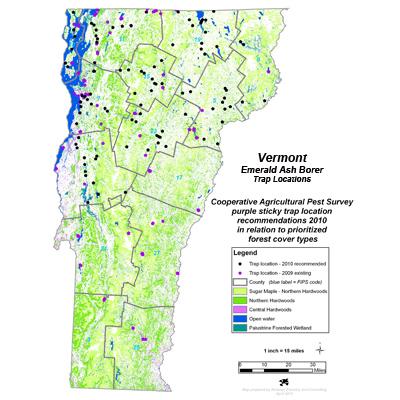
Developed by NSRC researchers in Vermont, ForAgProtect is a statewide geographic information system (GIS) for forestry and agricultural protection and provides collaborating forest protection managers with critical information for prioritizing and implementing early detection and rapid response, which play an increasingly important role in management in the Northern Forest. In a previous NSRC project, researchers used ForAgProtect to map hemlock stands, deer-wintering yards, nurseries, and seasonal residences to assess the risk of HWA introduction to southern Vermont.
This project expands that work to other NNIS. Researchers used ForAgProtect to prioritize purple sticky trap placement throughout Vermont for EAB detection; determine likely soil types for successful colony establishment of an EAB biocontrol wasp; locate second homes owned by residents of ALB-regulated areas outside Vermont; map pine plantations to use in surveys for Sirex wood wasp; recommend stream sites to sample for sudden oak death; and store location and health data of butternut trees as part of efforts to identify and propagate trees resistant to the butternut canker fungus.
Download printable version [PDF]
Download full final report [PDF]