Merging Landsat Time-Series and FIA Data to Develop Vulnerability Maps for Spruce Budworm Defoliation Decision Support
The eastern spruce budworm, a native pest to the northeastern United States and eastern Canada, has historically caused widespread defoliation, growth reduction, and death of balsam fir and spruce trees every 30 to 50 years. Mortality followed by salvage logging during past outbreaks dramatically affected forest structure, tree age distributions, productivity, wood supply, and wildlife habitat. The most recent outbreak occurred during the 1970s‐80s and, according to prevailing theory, the next outbreak is due. Without long‐term forest planning, budworm outbreaks create considerable uncertainty about future economic and ecological conditions.
Proactive planning for budworm outbreaks requires knowledge of host tree species distributions and forest vulnerability so that consequences of infestation can be better understood and effective policies and response strategies put in place. With the next anticipated outbreak approaching, suitable forest vulnerability data are required for planning and decision support across large, multi‐owner landscapes.
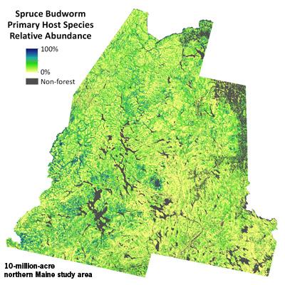
NSRC researchers developed methods to map budworm host tree species distributions and predict vulnerability of Northern Forest stands to defoliation using Landsat satellite imagery and forest data provided by USDA Forest Service Inventory and Analysis (FIA) plots. They mapped forest vulnerability across a 10-million-acre northern Maine study area and incorporated satellite data into an existing spruce budworm decision support system to demonstrate potential utility for broad‐scale forest planning. Project outcomes provide the basis for a large landscape‐scale assessment of forest vulnerability ahead of the next budworm outbreak and demonstrate the utility of low‐cost satellite‐derived data for forest planning and decision support. Methods are widely applicable to other research and management questions and are transferable to other regions.