Quantifying Disturbance to Forest Structure with Optical, LiDAR, and SAR Remote Sensing
Disturbance (such as wind, ice storms, disease, insect infestation, pollutants, or climate change) is a frequent occurrence in Northern Forest ecosystems. Timely and accurate assessment of disturbance events is critical for land managers to respond effectively. Assessing severity of disturbance (amount of tree damage or loss) across the landscape is vital for broad-scale management, policy, and economic decision making. Many of these disturbances produce only partial damage to forest structure, so they can be challenging to detect and quantify using conventional optical remote sensing techniques.
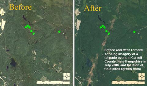
New satellite remote sensing technologies, such as synthetic aperture radar (SAR) and light detection and ranging (LiDAR), when combined with optical imagery, have the potential to identify disturbance and quantify its ecological effects more precisely than with optical imagery alone. NSRC researchers combined field-collected forest measurements from sites in New Hampshire and Maine with remotely sensed imagery to design and evaluate a blueprint operational image analysis system.
Researchers determined that forest disturbance monitoring that integrates remote sensing (Landsat, PALSAR, & MODIS) is feasible and cost-effective. Cost-effective, operational LiDAR is most likely more than a decade away; until then it’s a research tool. New SAR missions (Sentinel-1 and ALOS-2) can make noteworthy contributions towards monitoring disturbance at moderate scales (a few hectares) for the next decade. Researchers produced an open access field measurements database (http://nsrc.appliedgeosolutions.com/); regional maps of forest type, biomass, and canopy fractional cover; as well as higher resolution images of the study areas.