Comparing and Improving Model Estimates of Forest Carbon Storage in Northeastern Forests

Accurately measuring carbon stored in forested landscapes is crucial to understanding how changes in land cover may affect global carbon cycles. Improved carbon assessments can inform decisions about land use by identifying valuable conservation areas of high carbon storage. Better assessment of stored carbon could alter estimates of the value of conserved forestland in carbon markets.
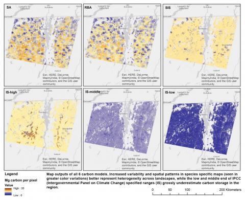
Because existing methods for calculating carbon storage at a landscape scale can be highly inaccurate in mixed tree species landscapes, NSRC researchers tested four carbon storage models for the Northeast and field validated each. Researchers calculated and compared carbon stored across the Northern Forest region at a snapshot in time (2014) using input spatial imagery methods with varying gradations of detail: dominant tree species or forest type (SA); percent basal area of forest type (RBA); IPCC (Intergovernmental Panel on Climate Change) guidelines based on general forest types and high, middle, and low carbon storage estimates (IS); and Smith-based IPCC style (SIS) including greater detail on tree species.
Researchers determined which models are over- or under-predicting carbon storage and by what magnitude. The traditional method outlined by the IPCC significantly underestimates carbon storage in the Northeast and misses the spatial variability found in mixed forests. The higher specificity models produced more accurate results and reflected heterogeneity that is more indicative of the species patterns in the Northern Forest. Maps produced will be used in a new decision support tool to allow land managers to highlight key conservation areas based on carbon storage and to better understand the role of northeastern forests in global carbon storage.
