Landscape-Scale Forest Carbon Estimation in a Northern Forest

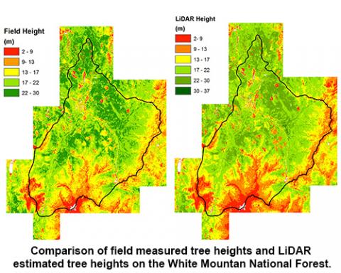
Many land managers in the Northern Forest region are abandoning expensive field-based forest inventory. However, to make sound decisions, managers need accurate estimates of forest carbon and habitat structure, especially at the landscape scale and for measuring ecosystem services provided by the forest. An emerging approach combines LiDAR (Light Detection And Ranging), which uses lasers to measure tree heights from aircraft, with field measurements to develop estimates of forest structure, biomass, and carbon.
NSRC researchers evaluated a combined LiDAR and field-based method, suggested by Asner et al. (2011) for tropical forests, to see if it can reduce inventory costs and increase accuracy under Northern Forest conditions. Researchers processed LiDAR data, collected by a commercial vendor, to produce various data layers (e.g. canopy height, canopy cover). They combined these structure metrics with standard data collected by field crews on New Hampshire’s White Mountain National Forest. They also conducted bird surveys to develop habitat assessment tools.
Researchers found that moderate resolution LiDAR data were adequate for developing maps and data products useful to managers. A simple canopy cover metric performed well in predicting early successional bird habitat. However, due to lack of a relationship between tree basal area and LiDAR height metrics, the Asner et al. approach performed poorly when estimating live biomass in this forest type. While a satisfactory approach has not yet been developed for estimating forest biomass from LiDAR data in a way that is operationally feasible for Northern Forest managers, LiDAR data of moderate resolution can be useful for characterizing the Northern Forest and has application for managers.
