Development of Functional Ecological Indicators of Suburban Sprawl for the Northeastern Forest Landscape
The term urban sprawl is used to describe an inefficient pattern of development where the economic, social, and environmental impacts are high relative to services provided. Experts have defined indicators of sprawl in terms of its social and economic impacts, but few have attempted to identify indicators of sprawl based on environmental impacts. NSRC researchers developed environmental indicators of suburban and exurban sprawl that consider per capita impacts and are specific to northeastern forests.
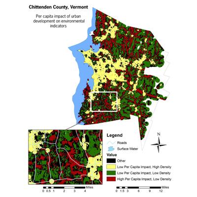
These indicators were used to track the environmental impact of development relative to the number of people housed and employed. Areas of dense urban development result in a high impact, but the large number of people served keeps the per capita impact low. On the other end of the curve, sparse rural development also has minimal impact per capita. In between those extremes, impact per capita increases. Researchers determined where certain development patterns fall along the curve by studying existing data on impacts of urban development on environmental indicators (wildlife habitat fragmentation, biodiversity, and water quality).
Using GIS (geographic information systems), researchers created two maps for Chittenden County, Vermont. One showed where densities and arrangements of development are most and least efficient based on population density, soils, water, topography, and natural ecosystems. The second map showed the estimated environmental impacts of new development in undeveloped areas. Planners in Chittenden County can use the data and maps, and planning agencies in the Northern Forest region can replicate the GIS methodology.
Download printable version [PDF]
Download full final report [PDF]