Developing and Testing a Third Party Landscape Forest Sustainability and Biodiversity Monitoring System
Forest stand level indicators of sustainable forest management have been developed and implemented through certification programs like Forest Stewardship Council (FSC) and Scientific Forestry Initiative (SFI). Few studies, however, have developed effective methods for assessing forest condition and patterns across landscapes and multiple ownerships to aid land stewardship and management at the ownership, watershed, or regional level. Regional vegetation maps combined with Landsat time-series satellite imagery and GIS data provide a powerful, cost-effective tool to monitor forest landscape conditions and trends.
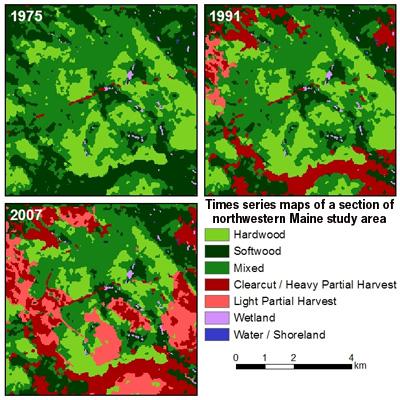
NSRC researchers analyzed several dates of Landsat imagery for a 1.8 million hectare study area in northwestern Maine. Combining a spatial database of private landownership change (1994-2007) with the time-series harvest maps, researchers calculated harvest rates (1973-2007) for parcels, summarized by owner and owner change history. They produced a forest cover time series (1975-2007) map for each parcel to quantify patterns of forest cover change over the 30-plus year period and calculated metrics (measures) for parcels of similar ownership to derive landscape patterns and change over time.
Researchers observed a decrease in extent and aggregation of large patches of intact mature forest in northern Maine. Land owned by timber investment management organizations and real estate investment trusts had significantly higher harvest rates in the 2000s. Patches of regeneration have become more dispersed since spruce budworm salvage logging (1973-1988) and implementation of the Maine Forest Practices Act in the early 1990s. Intact mature forest within parcels managed under a Working Forest Conservation Easement (WFCE) tended to be more extensive and connected, following a trend pre-dating the WFCE.
Download printable version [PDF]
Download full final report [PDF]