Evaluating Spatial Patterns in Mercury and Methyl Mercury in Northeastern Lakes: Landscape Setting, Chemical Climate, and Human Influences

Mercury contamination of surface waters and plant and animal life is widespread in the Northeast. Although mercury’s pathway through watersheds is complex, researchers have found that landscape features, such as number of wetlands near a lake, and lake chemistry variables, such as dissolved organic carbon (substances that make water iced-tea colored), are related to relative amounts of mercury in surface waters.
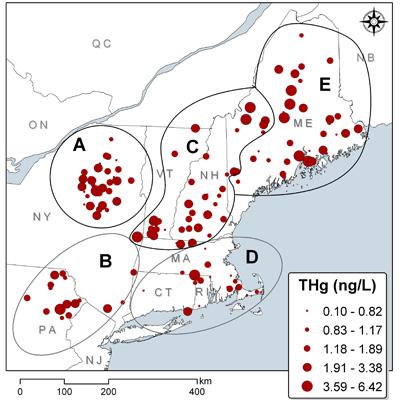
NSRC researchers investigated whether such watershed and lake characteristics could be used to predict mercury in lakes. If resource managers could predict mercury in lakes and aquatic organisms, they could target fish consumption advisories to specific lakes that are higher in mercury, rather than providing blanket advisories covering whole regions. Researchers linked statistics about the landscape, calculated from maps, to a northeastern regional lake dataset containing mercury and other lake chemistry variables collected in 1984, 1986, and 2004 by the U.S. Environmental Protection Agency.
Researchers developed and compared statistical models that predict mercury from the dataset. They found that smaller lake volume, larger watershed area, and greater levels of dissolved organic carbon tended to predict greater mercury levels. For Maine, dissolved organic carbon alone explained over 86% of the variability in mercury and was therefore the most important predictor of mercury. These findings suggest that it is possible to predict mercury concentrations in lakes, but both chemical and landscape variables are needed for the best predictions with the lowest margins of error. Future research on dissolved organic carbon compounds, different in each lake system, will help to better understand the relationship among dissolved organic carbon, landscape features, and mercury.
